
Yea what the title says, can you people post some up, i love this kinda stuff but whenever i google it or youtube or google video i just find that ancient aliens show.
Fictional accounts are cool too as long as its not corny shit
reps will be given


Yea what the title says, can you people post some up, i love this kinda stuff but whenever i google it or youtube or google video i just find that ancient aliens show.
Fictional accounts are cool too as long as its not corny shit
reps will be given

go back a few pages in KTL, their was a thread on the show, a few months back
The Anunnaki will back soon.
It was fake. Just a hoax.
are u referring to the cubed square on the history channel? or a freemasonic ritual?Originally Posted by Tectrus Moa

lets have some fun, strictly non-fictional.
http://projectavalon.net/lang/en/klaus_dona_en.html
Joshua P. Warren sent us this 1930s photo of a boulder in Western North Carolina covered with strange, ancient carvings. According to legend, they were made by a terrible, slant-eyed giant. However, Warren thinks they might represent ancient depictions of microscopic life. For detailed comparisons, and other pics related to his investigation, visit http://www.joshuapwarren.com/
http://www.coasttocoastam.com/photo/43593
Heliopolis at Baalbek & Puma Punku Stone Carving
Giorgio Tsoukalous sent us two images to accompany his presentation. The first shows Heliopolis, Temple of the Sun god Baal, Baalbek, Lebanon. Notice how tiny the human is in comparison to the megalithic stones used, he writes.
Giorgio Tsoukalous sent us two images to accompany his presentation. The second picture shows the Puma Punku stone carving. "Today, to replicate such a formation we would use sophisticated computer technology. And the ancients, allegedly, did this with chicken bones and obsidian?," he asks.
http://www.coasttocoastam.com/photo/44451
shall i post more??
http://beinecke.library.yale.edu/dl_...?srchtype=ITEM
i got lots more interesting things like this to post..
which i will do, research these items
peace
Tiahuanacu (also called Tiwanaku) is a mystery because of its age (estimated to be 17,000 years) and the peculiar stone technology. Today there is little doubt that Tiahuanaco was a major sacred ceremonial centre and focal point of a culture that spread across much of the region. The ancient people built a stone pyramid known as the Akapana
Gateway of the Sun, Tiahuanaco
(courtesy of www.sacredsites.com and Martin Gray)
View of the Kalisasaya complex (Courtesy Alexei Vranich)

Entrance to Kalasayaya temple, Tiahuanaco, Bolivia
(courtesy of www.sacredsites.com and Martin Gray)That structure dominates the bottom half of this aerial photo.When first discovered the pyramid was largely covered with soil. After several decades of excavation some of the walls have been uncovered and treasure hunters opened a depression in the top. This was built originally to open towards the east. The dark line across the lower part of the picture is the railway line from a lakeside port to La Paz, the Bolivian capital. The rectangular outline just 'above and to the left ' of the Akapana is a terreplein. known as the Kalasasaya. The lighter patch with an indistinct outline 'above' the Akapana is where an excavated semi-subterranean 'temple' has been discovered. Other features are visible but most of the 'patches' are fields. The upper part of the picture is crossed by the road from the the village of Tiwanaku leading eastwards to La Paz. (taken from 'Pathways to the Gods' by Tony Morrison 1978).
continued http://www.world-mysteries.com/mpl_6.htm ....
(Left, above left & above) Terraces and steps: perspectives of the south face of the main monument, Yonaguni.
(Above right & right) Terraces and steps: prehistoric rock-hewn structures at Sacsayhuaman (above) and nearby Qenko (below) in the high Andes mountains of Peru.(Left) Turtle figure carved into the top of the eastern side of the main monument.
(Below left & below) Two views of the "Basin", a pool-like structure near the apex of the main monument. It features a right-angled internal corner, sheltered by surrounding elevations.(Above) View of the internal right-angle of the Basin. It is difficult to see how such a feature in such a protected setting could have been produced solely by natural forces such as waves or tidal action.(Right and far right) Graham Hancock diving in the "Basin" at Yonaguni.
(Below) A series of three vertical holes run in alignment along the Basin's straight edge. Some geologists have described them as pot-holes, which they may well be. However their direct and immediate association with another curious feature - the Basin itself - should force us to consider other possibilities as well.(Right) Megalithic entrance tunnel leading to parallel megaliths.
(Below right) Parallel megalithic blocks oriented east to west and lying at the north-west corner of the main monument.
(Below) Parallel megaliths with diver for scale.(Above) Curious feature, close to parallel megaliths, with an apparent curving sloped stone path flanked by parallel curving walls.
(Left) Second area of terracing half a kilometre south of the main monument. Found at the base of a sheltered east-west defile and at a depth of 27 metres, it could not have been subjected to the &wave and tidal forces& that some geologists believe were responsible for the Yonaguni anomalies.
(Left & right) Two-ton megalith surmounting a carved platform 300 metres to the east of the main monument.
http://www.grahamhancock.com/gallery...r/yonaguni.htm
(Left) 'Olmec' head from la Venta, Gulf of Mexico, approximately 1500 BC. Current theories of racial dispersal cannot explain the presence of this negroid face this early in the Americas.
(Right) 'Olmec' head, La Venta.(Far left) 'Olmec' head, la Venta.
(Left) Head of the Old Man, La Venta. Compare with the features of the Great Sphinx of Egypt - see Gallery 2, image 5(Right) Figure from La Venta known as 'the walker', seeming to show a bearded man with Caucasian features.
(Far right) Image of bearded Caucasian from Monte Alban.(Left) Image of bearded Caucasian from Monte Alban.
http://www.grahamhancock.com/gallery/mexico/2.htm
I dont totally go along with this chronology.. but its a nice read:
http://www.phenomenica.com/2008/09/u...ne-part-1.html
UFO Timeline - Part 1
6,000,000,000 B.C. Celestial force controllers materialize Andronover Nebula. It
subsequently gives birth to 1,013,628 sun systems
4,500,000,000 B.C. Planets of the current Solar System spun-off from sun.
1,000,000,000 B.C. Earth attains its present size and forms stable crust.
550,000,000 B.C. Seeds of life formulated and planted at three locations in Earth's primeval seas by extra planetary life carriers.
500,000,000 B.C. Animal life evolves off by a factor of 4.
1,000,000 B.C. First primitive humans - identified by appearance of free will in mammals.
1,000,000 B.C. to Present: various non-human life forms visit Earth. ETs begin genetic, psychological, and spiritual "modifications" with resident races.
500,000 B.C. Extra planetary beings come to Earth to "uplift" resident races.
445,000 B.C. The book of Enoch describes the Nephilim descended on Mt. Hermon.
432,000 B.C. Anunnaki arrived in the Persian gulf area, colonizing the planet… merged their genes to produce us, Homo Sapiens.
200,000 B.C. Resident extra planetary beings rebel against universe authorities.
75,000 B.C. - according to Scientology Xenu was a galactic ruler, who ordered the Nuking of the Earth. Fused Green Glass indicative of a nuclear explosion has been found in the Egyptian desert; Euphrates Valley; Gobi Desert; Iraq; Libyan Desert; lop Nor Desert, China; Mojave desert; Pierrelatte, Gabon; Scotland and Turkey. Highly Radioactive Skeletons were found in Rishi, Mohenjudaro, Pakistan.
47,000 B.C. Objects, resembling cylindrical spacecraft and occupants, carved on rocks in Hunan Province, China.
12,000 B.C. to 9,000 B.C. Atlantis: An island nation located in the middle of the Atlantic ocean populated by a noble and powerful race. The island was a center for trade and commerce for Europe and Africa…
12,000 B.C. - Paintings in caves in Northern Spain and Southern France depict Disc-like Objects.
12,000 B.C. - Soviet Scientists discover "Age-old Instruments" with Mercury inside, in caves in the Gobi Desert and Turkestan. Dating back to 12 000BC.
11,000 B.C. - A Meteorite catalogued as ALH84001 from Mars crashed into Antarctica.
10,000 B.C. - The Dropas - In 1938 archaeologist Chi Pu Tei discovered regularly aligned rows of graves in the Baian Kara Ula mountains near the Sino-Tibetan border. Beneath cave drawings of beings wearing helmets along with depictions of the stars, sun and moon, small frail skeletons with unusually large skulls were found. Chi Pu Tei theorized that the skeletons belonged to an extinct species of mountain ape and that the drawings were left in the caves by human tribes. Since the graves were in systematic rows, his theory was laughed at and forgotten until 1962, when stone plates found among the graves were translated by Professor Tsum Um Nui of the Academy of Prehistoric. The translation told an eerie story of a group of beings that crash-landed on the third planet of this star system about twelve thousand years ago. Unable to repair their craft, this group attempted to make friends with the mountain tribes but were hunted down and killed due to their non-human features.
10,000 B.C. Lemuria: A civilization which existed prior to and during the time of Atlantis. Most of what is written is metaphoric - linking to the patterns of creation and sacred geometry. Physically, it is believed that Lemuria existed in the Southern Pacific, between North America and Asia/Australia. Lemuria is also sometimes referred to as Mu.
8,000 B.C. - Australia - The Aborigine believed in "Dawn Beings" from the Stars. Their cave paintings depict Celestial Beings, with Antenna and X-Ray style drawings. They were very advanced in "Aerodynamics". The Boomerang is identical to modern day Aircraft's Wing. Aborigine means "From the beginning".
6,000 B.C. Sumer, amazing in its "sudden", mature, and highly advanced character, was set up under Anunnaki tutelage in Mesopotamia… Humans were taught technology, mathematics, astronomy, advanced crafts and the ways of advanced civilized society…
4,000 B.C. Creation of Adam and Eve.
4,000 B.C. - The Sumerians from today's Iraq had contact with Extraterrestrial (ET) civilizations according to their text. The ET's also interbred with Humans and their Kings traveled to the Stars with ET's. Sumerian text coincides with "The Book of Genesis". Their Astronomy was highly developed. They had numbers with 15 Digits. Their text stated the ET's were from Mars, Pleiades Star Cluster and Sirius. They had drawings of our Solar System.
3,000 B.C. - China - The book, "Memories of the Sovereigns and the Kings" published in the 3rd Century AD wrote of "Sons from the Sky", would descend to Earth on a Star which was shaped like a Saucer.
3,000 B.C. Incarnation of Melchizedek.
3,000 B.C. - Sumerians interact with the Reptilian Annunaki.
2,700 B.C. - Egyptian 365 Day Calendar.
2,345 B.C. - China - In the, Hsui-Nan-Tzu, a Chinese classic there is a description of 10 Suns appearing in the sky.
2,029 B.C. - Abram (Abraham) born in UR (South Chaldea)
2,000 B.C. Grand Canyon Flagstaff, Ariz. - A team of experts called in to examine strange debris at the bottom of the Grand Canyon discovered the wreckage of a UFO that crashed a mind boggling 4,000 years ago. The scientists, members of a highly secret joint military task force on UFOs, inspected the spherical craft and found it to be in good condition despite its rough landing and incredible age. The relic is made of an unknown metallic substance and emits low levels of radiation, according to leaks from highly placed sources. It was immediately removed from the site and is now in a secret location. My contacts tell me this craft is definitely of extraterrestrial origin and without a doubt carried a crew of 12 to 20 individuals, said Dr. Henry Leaumont, a California based astronomer who contacted this reporter after he was shown secret air Force documents relating to the find. Carbon dating shows it crash landed at the base of the canyon around 2,000 B.C. Cabin features suggest that the crew members were much like humans, although significantly smaller. They apparently breathed oxygen, guided their atom powered craft with a magnetic steering system and carried supplies of food and water on board. According to reports filed by the scientific team, the spacecraft was lodged in limestone rubble at the base of the canyon not far from an area called Comanche Point.
1,500 B.C. to 1,000 B.C. Egyptians: Observed numerous flying objects Egyptian carvings of flying objects (Found on the ceiling beams of a 3000-year old New Kingdom Temple, located several hundred miles south of Cairo and the Giza Plateau, at Abydos.) The Great Pyramid of Cheops and the Temple of Hathor are both connected to the Pleiades.
624 B.C. - Incarnation of Buddha.
592 B.C. - The Book of Ezekiel records a strange "wheel" coming from the sky and landing near the Chebar River in Chaldea (now Iraq). The writing references creatures emerging from the vehicle.
400 B.C. - India - The Mahabbarata spoke of Blazing Discs burning and destroying an entire City and its Inhabitants, before returning to the hand of Vishnu.
332 B.C. - Tyre, Phoenicia - During the Greek siege of Tyre, a fleet of Flying Shields plunged from the sky and crashed upon the City's walls.
329 B.C. - Alexander the Great told of Two Strange Objects repeatedly diving at his Army. Described as great Silver Shields spitting fire around the rims.
300 B.C. - Mayan Calendar based on Advanced Astronomy.
246 B.C. - Primitive Battery invented in Iraq.
223 B.C. - Rome, Italy - "At Ariminium a Bright Light like day blazed out at Night; in many portions of Italy Three Moons became visible at night". - Dio Cassius, Roman History, Book I.
222 B.C. - Rome, Italy - Also Three Moons have appeared at once, for instance in the Consulship of Gnaeus Domitius and Gaius Fannius". - Pliny, Natural History, Book II, Ch. 32.
218 B.C. - Rome, Italy - Glowing Lamps were seen in the sky at Praeneste, a shield seen at Arpi and in the Amiterno District the sky was all on fire, and Men in White garments appear.
217 B.C. - Flaleri, Italy - The sky seemed to be rent as if it were with a Great Fissure and through the opening a Bright Light had shone - Livy, History Book XXII, Ch. 1.
216 B.C. - "Things like ships" were seen in the sky over Arpi -- 180 Roman miles, east of Rome, in Apulia. (From the Roman author Julius Obsequens in, "Prodigorium Liber.")
214 B.C. - Hadria, Italy - An Altar was seen in the sky and about it the forms of Men in White clothes. - Julius Obsequens, Prodigiorum Libellus, Ch 66.
170 B.C. - At Lanupium a "Fleet of Ships" was seen in the sky.
163 B.C. - Formice, Italy - "In the Consultship of Tiberius Gracchus and Manius Juventus at Capua the Sun was seen at night. At Formice Two Suns were seen by day. The sky was afire. In Cephallenia a trumpet seemed to sound from the sky. There was a Rain of Earth. A Windstorm demolished houses and laid crops flat in the fields. By night an apparent Sun shone at Pisaurum". - Obsequens, Prodigiorum, Ch. 114.
122 B.C. - Gaul, (France) "In Gaul Three Suns and Three Moons were seen". - Obsequens, Prodigiorum, Ch. 114.
99 B.C. - According to C. Murius and L. Valerius, consuls in Tarquinia, "a round object like a globe or circular shield took its path in the sky, from west to east." (From the Roman author Julius Obsequens in, "Prodigorium Liber.")
90 B.C. – The Prodigia of Julius Obsequens reported at Aernarie, Italy a terrific noise and a "Globe of Fire" burning in the North and in the Spoletum Territory a Golden colored "Globe of Fire" descended and ascended into the sky.
90 B.C. - Rome, Italy - In the territory of Spoletium, in Umbria, a Globe of Fire, of Golden colour appeared burning in the North waith a terrific noise in the sky, the fell, gyrating to the Earth. It seemed to increase in size, rose from the Earth, ascended into the sky, where it obscured the disc of the Sun, with all its brilliance. It revolved towards the Eastern quadrant of the sky.
85 B.C. - Italy -"In the Consulship of Lucius Valerius and Caius Marius a Burning Shield scattering sparks ran across the sky". - Pliny, Natural History, Book II, Ch. 34.
81 B.C. - Spoletium, Italy - "Near Spoletium a Gold-coloured Fireball rolled down to the ground, increased in size; seemed to move off the ground toward the East and was big enough to blot out the Sun". _ Obsequens, Prodigiorum, Ch. 114.
73 B.C. - Pontus, Asia Minor - Whilst Roman legions were engaged in battle near the Black Sea against King Mithridates, a huge flaming Object fell between the two armies. It was said to have a shape like a Wine Jar and was the colour of molten lead.
im done for now.. but i got lots more..
peace
thanks SC, this is the kind of stuff i been looking for.
kidha jasjit!
i think i misread your original post, you want shows??
im afraid the shows are pretty shit, unless u look for videos of seminars on youtube..
but the best information is from reading..
if you want to search for seminars,,
search for these people:
carl johan callaman
michael bara
david childress
logan hawkes
jason martell
marco wasi
erich von danichen
robert m schoch
graham hancock
visit redice radio, check their radio archies.. some really amazing interviews on their
everything i ve mentioned in here, their should be video/audio on the net.. lol
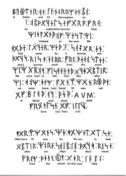
It all started in 1898 when the ten year old son of Olof Ohman, who was farming two and half miles northeast of Kensington, found strange markings on a slab of rock that had just been pried out of the ground. The son, Edward, called his father's attention to the stone.
The father, who had been clearing trees and rocks from a level space on top of a hill 40 feet above the surrounding low land, saved the stone, and later showed it to prominent citizens in Kensington. No one was able to completely decipher the stone, until nine years later when Hjalmer R. Holand, a University of Wisconsin graduate student with a major in history, heard of the stone on a trip to Kensington.
Mr. Holand translated the stone and found it to read,"8 Goths and 22 Norweigans on exploration journey from Vinland over the west. We camp by 2 skerries one day-journey from this stone. We were and fished one day. After we came home, 10 men red with blood and tourtured. Hail Virgin Mary, save from evil. Have 10 men by the sea to look after our ship, 14 day -journeys from this island year 1362."
The translation of this stone sparked an international search to find out if it could possibly be genuine. The Minnesota Historical society appointed five scholars to investigate, and after a year and half of work reported the stone genuine.
The Kensington Runestone is 31 inches high, 16 inches wide, six inches thick and weighs 202 pounds.
This is how the expedition, 130 years before Columbus started:
Navigator for the crews was Nicolas of Lynn, an English astronomer who was known throughout Europe. He brought the small ships safely to Iceland, Greenland, Rhode Island and Hudson Bay. While the main party went south looking for a safer way back to New England than the bitter cold northern route, he mapped the whole of Hudson Bay and discovered, for the first time in history, the magnetic North Pole.
The sons of Columbus said the discovery of islands in the west by Lynn, was one of the factors which encouraged his father to try the southern route to America. A map by John Ruysch, dated 1508, refers to the discovery of the magnetic North Pole as an accomplished fact. In 1537 a map was published of Hudson Bay showing the discoveries of Lynn, which included such details as spring thaws which flooded to the north.
The American evidence is equally extensive.
A series of 15 campsites have been found, running from Hudson Bay to Sauk Centre, Minnesota. The Vikings, as is still the case in Norway, cut triangular holes in convenient rock ledges to which to fasten anchor pins for their boats.
Because the Indians or early settlers to Minnesota did not use such type of holes, these mooring holes are distinctive and have not been molested. They are so old, the rain and sand have worn the tiny chisel marks on their inner surfaces smooth. Several have been found at projected intermediate places along the route.
There are a number of actual 1362 period Norse instruments, which have been taken to Europe and found to be identical with similar instruments in the Nordic museum near Stockholm and other museums.
These instruments have been found in no other place in the North American continent showing they could not have been brought to this country by settlers.
These instruments include a firesteel for making fires; a ceremonial halbred signifying a royal expedition; a heavy battle axe with a 16 inch cutting edge; a light battle axe, used for fighting men in armoured suits; a spear head; a Nordic sword, and other relics which include mooring stone pins.
The Verendrye Runestone was found in 1783 near Minot, North Dakota. It was fitted into a pillar, had runic markings on both sides and was about 5 inches wide and 13 inches long. Indians who were asked about the stone said it had been part of the pillar since time immemorial.
Verendrye, a French explorer, took the stone to eastern Canada, where it was studied by Jesuit priests, and then he took it to France where it became lost. The Minnesota Historical Society has offered a $1,000.00 reward for its rediscovery.
Mr Holand says it may well have been found in Mandan territory and that it may carry an additional message from the Vikings who lived out their lives with those Indians.
There are blue-eyed Mandan Indians who knew about Christianity before the first settlers arrived, and who lived in square medieval-Norwegian design buildings. It is believed that the main party which went south from Hudson Bay had a special religious service at Sauk Centre at a huge stone alter there and then turned back north to rejoin their comrades.
However, due to accident, fire, error in judgment, or unexpected severe fall headwinds, they were unable to return in time to go with Lynn on his return back to Europe. So, they cast their lot with the Mandan Indians, widely known for their noble mode of life.
http://www.kensingtonmn.com/runestonepg.html
The Museum of Natural History in London displays an early Paleolithic skull, dated at 38,000 years old, and excavated in 1921 in modern Zambia. On the left side of the skull is a perfectly round hole nearly a third of an inch in diameter. Curiously, there are no radial split-lines around the hole or other marks that should have been left by a cold weapon, such as an arrow or spear. Opposite the hole, the cranium is shattered, and reconstruction of the fragments show the skull was blown from the inside out, as from a rifle shot. In fact, any slower a projectile would have produced neither the neat hole nor the shattering effect.

Forensic experts who have examined the skull agree the cranial damage could not have been caused by anything but a high-speed projectile, purposely fired at the prehistoric victim, with intent to kill.
If such a weapon was indeed fired at the man, then one of two conclusions can be made: Either the specimen is not as old as it is claimed to be, and was shot by a European in recent centuries, or the remains are as old as claimed, and the marksman was ancient too. In view of the fact that the Paleolithic skull was excavated from a depth of 60 feet, mostly of lead rock, the second conclusion is more plausible.
But who possessed gunpowder 38,000 years ago? Certainly not Stone Age man himself. Another race must have existed, one far more advanced and civilized, yet contemporary.
The question is, where did that rifle-toting marksman call home?
Tiwanaku in Bolivia!
Precision stonework that confounds the experts of today.
http://www.crystalinks.com/tiahuanaco.html
...........Building was begun at some time before A.D. 500, and there is evidence of additional construction (c.11001300). About 1000, Tiahuanaco culture spread to E Bolivia, N Chile, and Peru; the culture flourished for about 200 years. Built of massive blocks weighing up to 100 tons and brought from several miles away, the structures of Tiahuanaco are superb examples of masonry. The stones, fitted together without mortar, were cut, squared, dressed, and notched with a precision equaled in no other aboriginal South American civilization, not even the Inca. Construction is largely of the platform or monolithic type decorated by conventional incised carving or heads in low relief. The creators of Tiahuanaco also excelled at ceramics; Tiahuanaco painted pottery is one of the great achievements of pre-Columbian art..............

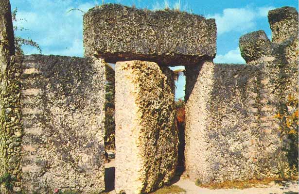
http://coralcastle.com/
http://www.crystalinks.com/coralcastle.html
Even from a basic engineering standpoint, Coral Castle completely blows my mind. Consider this:
* Edward Leedskalnin weighed less than 100lbs; he always worked alone, mostly at night, by the light of a lantern.
* Over 28 years he single-handedly quarried and shaped 1,100 tons of oolitic limestone.
* The stones in the castle weigh on average 15 tons each.
The largest stone weighs 30 tons and the tallest stones are two monolithic stones standing 25 feet (7.6 m) high each.
If I remember right, the average stone in Stonehenge weighs 20-25 tons, with the highest being 13 feet high above the ground. (If I'm off, feel free to correct me).
* At one point, he moved the entire structure, a process that took him three years.
* The stones are fastened together without any mortar. They are simply set on top of each other using their immense weight to keep them together. However, the craftsmanship detail is so skillful that the stones are connected with such precision that no light passes through the joints.
* The eight foot tall vertical stones that make up the perimeter wall have a uniform height. Even with the passage of decades and a direct hit on August 24, 1992 by the Category 5 Hurricane Andrew, which leveled everything in the area, the stones have not shifted.
* The most famous feature is a nine-ton, 8-foot tall revolving gate. The gate is carved so precisely that it fits within a quarter of an inch of the walls on both sides. It was so well-balanced that a child could open it with the push of a single finger.
* When the gate stopping working, in order to repair it, six men and a fifty ton crane had to be utilized. Once the gate was removed, the engineers discovered how Leedskalnin had centered and balanced the nine-ton piece of rock. Leedskalnin had drilled a hole from top to bottom of the eight-foot-tall gate with no electric tools and inserted a metal shaft.
But according to skeptics, all of the above was just done by one man working with pulleys and ropes...
No other forces needed, right?

Yes, the Coral Castle is a truly remarkable achievement. It seems Leedskalnin had obtained a secret knowledge from somewhere and it was clearly a secret that could not under any circumstances be shared. Otherwise, why not at least reveal some of the mystery before he died, that could maybe be of benefit to humanity.
But from who or where did this knowlwdge come from?
This revolving door is particularly impressive:
Göbekli Tepe : Not only its large dimensions, but the side-by-side existence of multiple pillar shrines makes the location unique. There are no comparable monumental complexes from its time. Nevalı Çori, a well-known Neolithic settlement also excavated by the German Archaeological Institute, and submerged by the Atatürk Dam since 1992, is 500 years later, its T-shaped pillars are considerably smaller, and its shrine was located inside a village; the roughly contemporary architecture at Jericho is devoid of artistic merit or large-scale sculpture; and Çatalhöyük, perhaps the most famous of all Anatolian Neolithic villages, is 2,000 years younger.
Schmidt has engaged in some speculation regarding the belief systems of the groups that created Göbekli Tepe, based on comparisons with other shrines and settlements. He assumes shamanic practices and suggests that the T-shaped pillars may represent mythical creatures, perhaps ancestors, whereas he sees a fully articulated belief in gods only developing later in Mesopotamia, associated with extensive temples and palaces. This corresponds well with an ancient Sumerian belief that agriculture, animal husbandry and weaving had been brought to mankind from the sacred mountain Du-Ku, which was inhabited by Annuna-deities, very ancient gods without individual names. Klaus Schmidt identifies this story as an oriental primeval myth that preserves a partial memory of the Neolithic.[11] It is also apparent that the animal and other images are peaceful in character and give no indication of organised violence, i.e., hunting.
At present, Göbekli Tepe raises more questions for archaeology and prehistory than it answers. We do not know how a force large enough to construct, augment, and maintain such a substantial complex was mobilized and paid or fed in the conditions of pre-Neolithic society. We cannot "read" the pictograms, and do not know for certain what meaning the animal reliefs had for visitors to the site; the variety of fauna depicted, from lions and boars to birds and insects, makes any single explanation problematic. It is not known why more and more walls were added to the interiors while the sanctuary was in use, with the result that some of the engraved pillars were obscured from view. The reason the complex was eventually buried also remains unexplained. Considering that only a fraction of the site has so far been excavated, these and other mysteries may eventually be cleared up
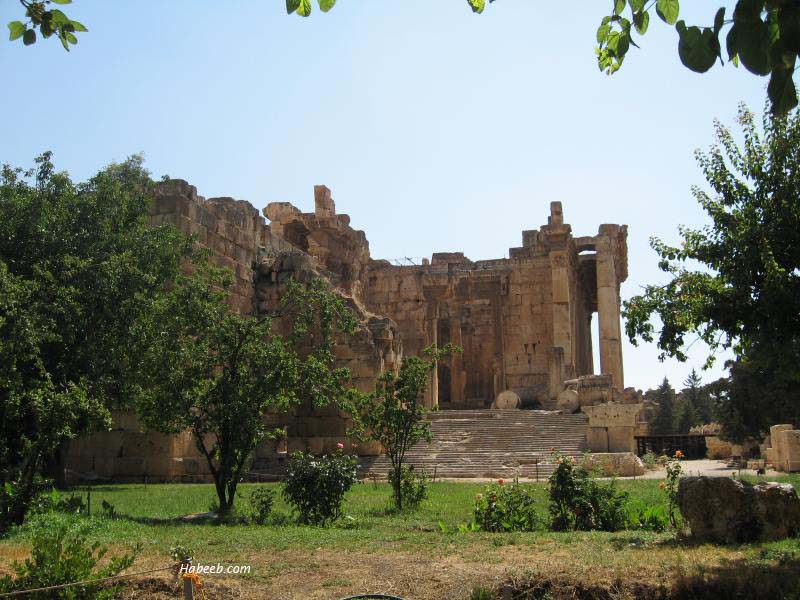
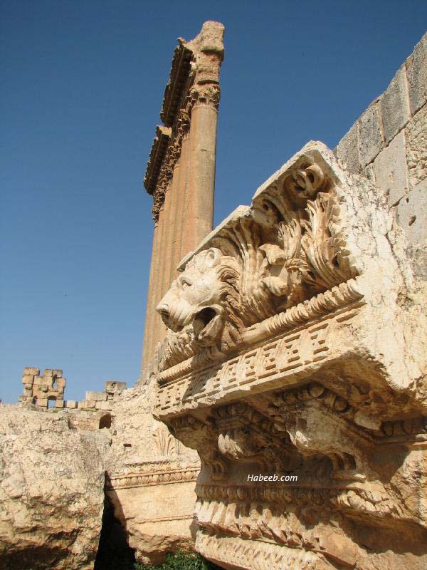
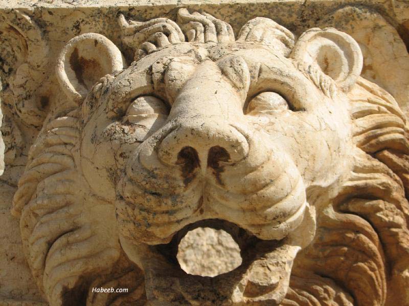
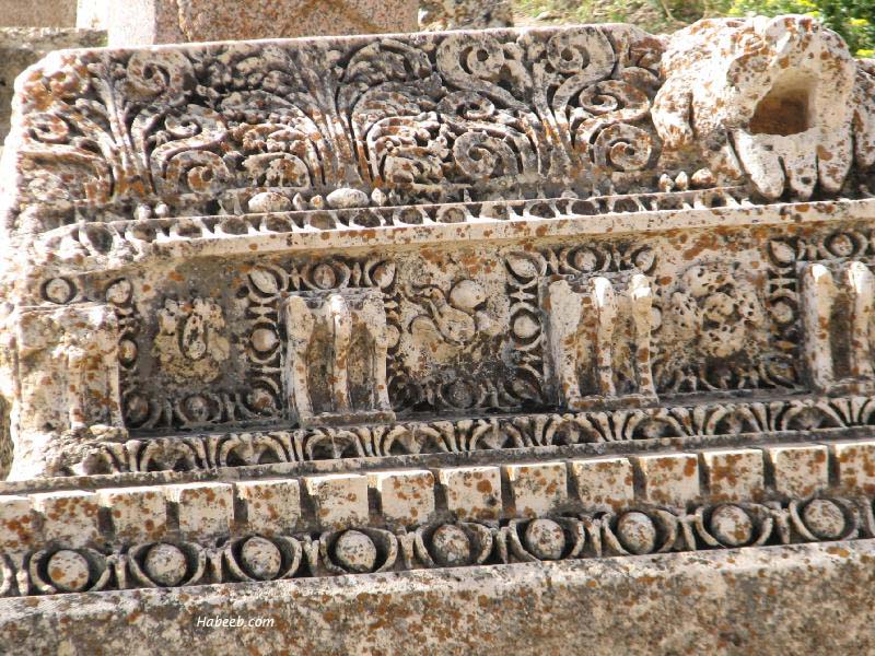
Photo - Baalbeck, Lebanon
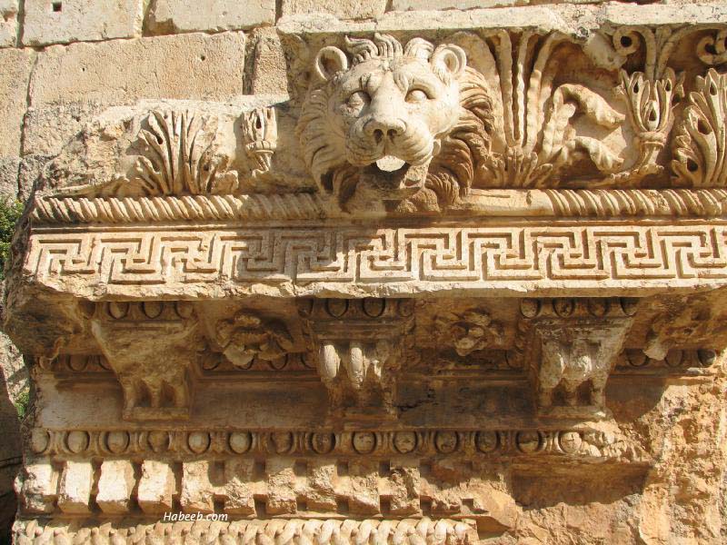
The famous lion's head laying on the ground in front of the famous pillars of the temple of Jupiter
Photo - Baalbeck, Lebanon
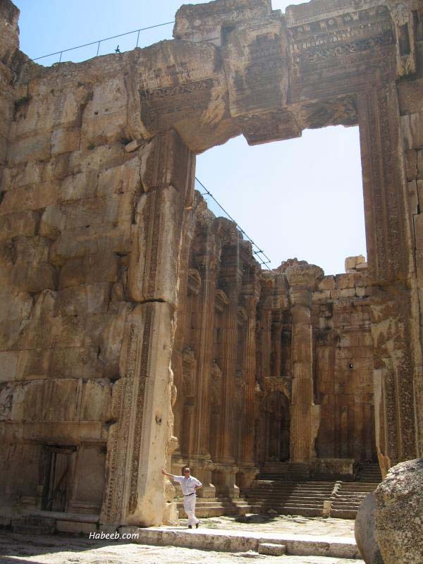
The Temple of Bacchus, viewed as the best-preserved old temple in the world
Photo - Baalbeck, Lebanon
Photo - Baalbeck, Lebanon
Another shot from a different angle: the Temple of Bacchus
Photo - Baalbeck, Lebanon
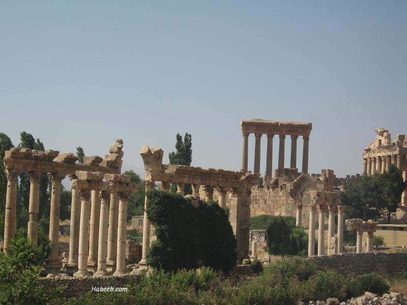
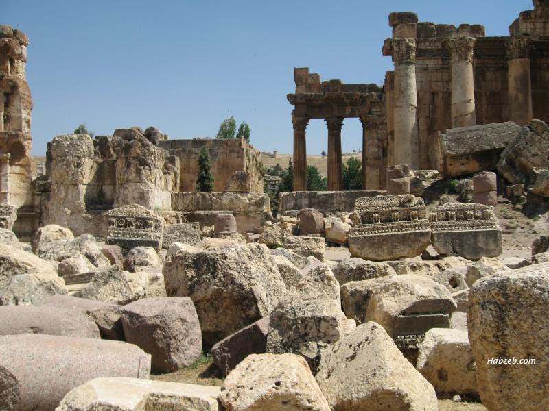
General view from the city of Baalbeck looking towards the temples with the snow-capped Mount Lebanon in the background
Photo - Baalbeck, Lebanon
Photo - Baalbeck, Lebanon
Photo - Baalbeck, Lebanon
Photo - Baalbeck, Lebanon
Photo - Baalbeck, Lebanon
An inside shot of the Temple of Bacchus
Photo - Baalbeck, Lebanon
Photo - Baalbeck, Lebanon
Photo - Baalbeck, Lebanon
Photo - Baalbeck, Lebanon
Photo - Baalbeck, Lebanon
Photo - Baalbeck, Lebanon
Photo - Baalbeck, Lebanon
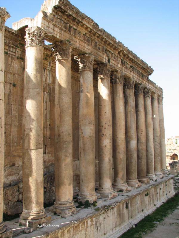
Gorgeous Corinthian-style columns
Photo - Baalbeck, Lebanon
Photo - Baalbeck, Lebanon
The Temple of Bacchus
Photo - Baalbeck, Lebanon
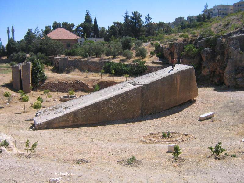
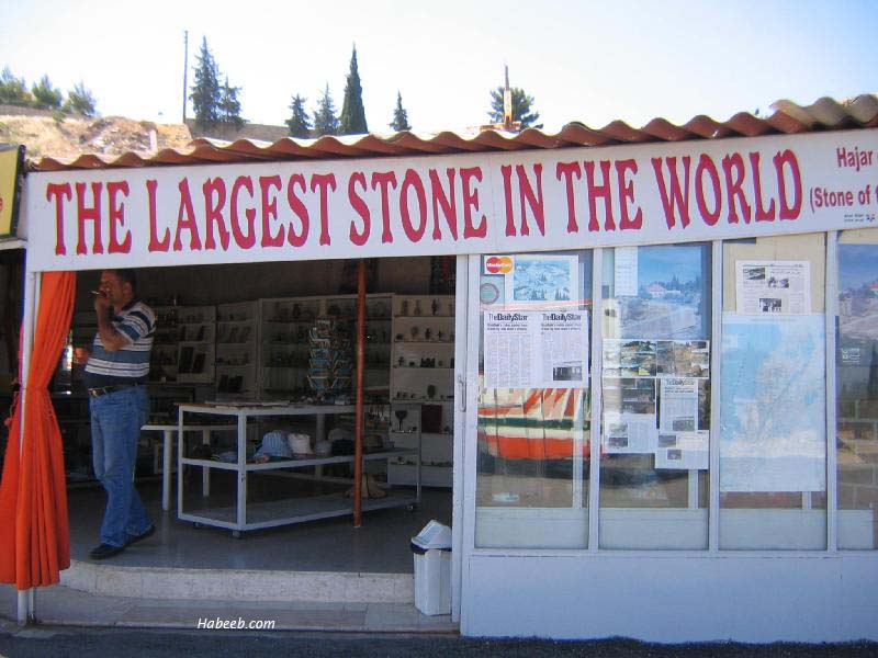
Largest stone megalith in the world, estimated to weigh 1,200 tons. As a reference, the stones used to build the pyramids in Egypt weighed 50 tons
Location: Baalbeck, Lebanon
Store with banner - largest stone in the world
Location - Baalbeck, Lebanon
Mount Lebanon as seen from Baalbeck, looking west
Baalbeck is in eastern Lebanon in the bekaa valley.
Lebanon has two mountain ranges. The western one (seen in the photo above) is called Mount Lebanon and is the higher of the two ranges.
while the eastern range is called the Anti-Lebanon range
The columns of the Temple of bacchus are on the right. Notice how small the two tourists are compared with the height of the columns.
To the left, in the distance are the famous six remaining columns of the Temple of Jupiter
Last edited by soul controller; 06-18-2011 at 04:52 AM.
Perched atop a hill in Newport, Rhode Island, an old stone tower stands as one of this country's longest enduring architectural enigmas. Known by many names, including the Viking Tower, Old Stone Mill, and Mystery Tower, today this landmark is more commonly known as the Newport Tower.
For over a century debate has raged over the identity of the builders of this structure. Speculation has ranged from the Norse to the Chinese to the Norwegians and Swedes. Most archeologists maintain that the tower was built in Colonial times and that there is no mystery surrounding its construction. But the full story of how this great monument came into being may not yet have been told.
Constructed of small slabs of unfinished stone held together with a mortar of shells, sand and water, the tower is built upon eight round columns separated by an equal number of arches supporting the remains of two upper stories. Now just over 24 feet in height, it once stood at least several feet taller.
Interestingly, the Newport Tower was not built around a perfectly circular plan. From southeast to northwest the diameter measures 22 feet, 2 inches, but when measured from east to west, the diameter lengthens to 23 feet, 3 inches.1 This thirteen-inch differential is only one of many strange design aspects and may be an important clue towards determining the purpose of the structure.
Now protected by a high fence, the Newport Tower today stands as the centerpiece of Touro Park. Its outward appearance didn't always look so rough though. At one time the sides were coated with a smooth coating of white plaster, the remains of which can still be seen clinging to the outer walls.
Archeologists and historians for the most part agree that Governor Benedict Arnold—grandfather of the Revolutionary War traitor—had the Newport Tower constructed in the mid 17th century. As evidence, they point to a passage in governor Arnold's will in which he refers to the tower as "my stone-built windmill."1
Of course Governor Arnold never actually states that he built the structure. He may simply have been referring to the pre-existing stone tower that now resided on his land. In any case, all the will really proves is that the tower was in existence prior to the Governor's death in 1677.
The most convincing evidence for the tower being of Colonial origin comes from archeological digs performed by W. S. Godfrey, Jr. in 1948 and 1949. Godfrey's excavations uncovered many artifacts, all dated to Colonial times. He even excavated beneath the stone columns where he uncovered a bootprint consistent with boots worn in the 17th century. These results logically led him to conclude that the tower was constructed around 1650.2
Further evidence for a Colonial origin was supplied in 1993 when J. Siemonsen had samples of the tower's mortar carbon dated. His results led him to conclude that the building was erected between 1500 and 1630, again placing construction in Colonial times.2 The scientific evidence seems insurmountable, but many still believe that there's more to the Newport Tower's origin than is readily apparent.
Skeptics point out that the method used to extract carbon dioxide from the porous mortar used in Siemonsen's carbon dating has a high potential for error. His results produced possible construction dates from as early as 1450 to as late as the 20th century. His pronouncement of a Colonial origin was based on an averaging of the dates obtained. These results seem questionable to say the least.
Furthermore, Godfrey's excavations uncovered fragments of the plaster that once covered the walls of the tower. These fragments, like many of the artifacts recovered, were found beneath the foundations of the columns.
It seems straightforward to presume that plaster was not applied until the structure was completed. Therefore it has been hypothesized that plaster was deposited beneath the foundation during a later operation designed to stabilize the tower at a much later date. Since Colonial artifacts were found with the plaster, it has been suggested that the tower was merely reinforced during Colonial times and that its initial date of construction was actually much earlier.
There is a vast amount of evidence for a pre-Columbian date of construction for the tower. Admittedly, much of it is circumstantial, but when taken as a whole a reasonably compelling case can be made for a pre-Colonial date of origin.
If the tower was built for Colonial use, what was its purpose? Governor Arnold's will seems to indicate that it was used as a windmill, the function of which would have been to grind grain into flour. But the tower's construction seems to be completely at odds with this supposed purpose.
In examining the eight pillars that support the upper walls of the tower, it can readily be seen that the columns do not sit flush against the upper walls. In fact they overhang the upper levels by several inches. Proponents of the theory that the Norse constructed the tower point out that this design was a common feature of medieval European baptisteries where an outer structure would be built around the central stone core.1
The small ledges at the tops of the columns served to support wooden beams upon which the outer structure could be anchored. However, if the tower were really built as a windmill, this outer structure would have interfered with the spinning sails used by all windmills to harness the power of the wind. It seems difficult to fathom how these two contradictory design elements could have coexisted.
The basic eight-pillar design of the Newport Tower is also highly questionable for a windmill. As Jim Brandon points out in Weird America, "Windmills are subject to strong torquing forces and a heavy stone mass atop the rather spindly circle of pillars would be a very poor engineering solution, besides being more difficult to build than, say, a solid wall construction."3
Most damning of all to the windmill theory is the presence of a fireplace built into the second story of the tower. The dust produced when grinding grain is highly flammable. Building a fireplace into a windmill seems utterly inconceivable.
Then there is the matter of the effort required to build such a structure. It is estimated that the tower contains more than six thousand cubic feet of stone weighing almost one million pounds, all of which had to be collected and carried up the hill for construction.1
It seems unlikely that during the 17th century such a large-scale building project would have been initiated in Newport. In the years when the tower is supposed to have been constructed, the townspeople lived in constant fear of attack by the natives. Indeed their battles with the native Indians and the constant threat of attack did not end until 1676 when the colonists finally dealt the Indians a crushing defeat.1
If the labor were being put towards the construction of a defensive fort, it might make sense.But the construction of a fanciful windmill doesn't seem to correlate well with the circumstances of the times the colonists lived in.
So if Governor Arnold's contemporaries didn't build the tower, who did? Popular local opinion has long held that the tower was built by the Norse. Henry Wadsworth Longfellow helped to popularize this theory with the publication of his poem "The Skeleton in Armor" in which he makes several references to the Newport Tower.2
Proponents of the Norse theory often point to the unit of measurement they believe was used during construction. Unlike other Colonial structures that were built using the English foot, the Newport Tower appears to have been based using an ancient Scottish unit of measurement known as an ell which is equivalent to three Norse feet.4
In "America: 1355-1364," H. R. Holand lays out a convincing case that the Newport Tower was constructed in the mid 14th century by an expedition consisting of Norwegians and Swedes. As evidence, he points out the structural similarities of the tower to the Church of the Holy Sepulcher in Cambridge,England and the Church of St. Olaf in Tunsberg, Norway.
A channel cutting into the wall of the second story appears to have been designed to hold a slab of stone that could be used as an altar. Holand points out that small alcoves built into the wall both above and below the channel likely held relics and items of religious import. The design and orientation of this altar is consistent with practices of Catholic worship. However, there were no Catholics present among the early colonists of Newport during the 17th century.1
In 1946 Professor P. Luvfold and M. Bjorndal discovered a Swedish-Norwegian runic inscription on the west side of the tower, 14 feet above the ground. The inscription was translated as the date 1010.2 After a few minutes of searching, I located the proposed runic letters. The markings are very faint and crude.
The image on the left shows the inscription as it is supposed to appear. The middle photo highlights the markings as I saw them. The photo on the right shows the bare stone without enhancements. The runes could have faded or perhaps my vantage point wasn't ideal, but nevertheless, the inscription looks to be anything but conclusive.
In the June, 1977 issue of FATE, Clyde Keeler describes another inscription that he believes attributes the building of the tower to the Christian monk, Henrikus Gnupson.5 Again the photo on the left shows the letters as Keeler describes them. The middle picture depicts the markings I saw and the right photo shows the unenhanced stone.
There are a number of problems with this "rune" that is supposed to spell out IHC. During my inspection of the rock, I could find no trace of the supposed C. Furthermore, the I and H can only be read by selectively accepting and ignoring the markings on the rock.
Like other forms of rock art, there is no accurate way to date when these markings were carved into the stone. Certainly the first inscription existed by 1946, but there's no way to rule out a recent hoax. This all assumes that the markings are genuine inscriptions; a fact I'm not completely convinced of.
The most recent theory proposed to explain the Newport Tower's origins comes from the book "1421 – The Year China Discovered America." As the title suggests, the author Gavin Menzies theorizes that the tower was built by early Chinese explorers during the 15th century to serve as a lighthouse.
This startling revelation is based on a comparison of the Rhode Island tower to a similar structure used as a lighthouse in the port of Zaiton in Southern China. The towers do look alike; each built atop eight columns and once covered in smooth plaster. Other design elements such as the windows and fireplace are also similar.6
A definitive identity for the builders of the Newport Tower is still unknown. But there are many clues that once unraveled, may lead to a satisfactory explanation.
Menzies suggests that a chemical analysis could determine the composition of the mortar used to build the tower. Chinese mortar is unique and highly dateable having bits of rice ground in amongst its other components.6 The city of Newport has not allowed these tests to be carried out yet, but if they do, a Chinese origin could either be proven or ruled out.
The design of the tower itself still holds a number of unsolved mysteries as well. For instance, why does the diameter of the tower vary by a full 11 inches? This discrepancy is too big to attribute to simple builder error.
One of the most unique design elements in the Newport Tower is the inclusion of two chimneys built into the fireplace. During my research into the tower's origin I have yet to come across a satisfactory explanation for this architectural peculiarity. The identification of a similar chimney building style may well produce one of our best leads in determining who built the tower.
Recently, researchers used ground-penetrating radar to search the area around the tower. Their results indicated a number of unusual features that may be evidence for additional structures once surrounding the tower.7 These buildings may have been part of a church or baptistery for instance.
Of course the radar results, like much of the anomalous data surrounding the Newport Tower, is useless without hard evidence. A more extensive archaeological dig might just do the trick. A new excavation could probe deeper into the earth and perhaps determine if the tower really was merely reinforced during Colonial times.
However, such invasive research is unlikely to be approved by the city of Newport anytime soon. And even if it were, the results would still most likely be contested. Whether the work of the Chinese, the Norse or Colonial craftsmanship, the Newport Tower is undoubtedly one of America's oldest and most mysterious landmarks
http://www.unexplainedearth.com/newport.php
The Money Pit
Oak Island Money Pit Part 1: http://www.youtube.com/watch?v=Sw2E3xwO_M4
Oak Island Money Pit Part 2: http://www.youtube.com/watch?v=b49YE...eature=related
Oak Island Money Pit Part 3: http://www.youtube.com/watch?v=ELsURJxMSK0&NR=1
Oak Island Money Pit Part 4: http://www.youtube.com/watch?v=sXF1K...eature=related
Quote:
One can only wonder what would have happened if young Daniel McGinnis had chosen to go exploring somewhere else on that fateful day in the summer of 1795. If he had, perhaps nobody else would have walked the woods on the eastern end of Oak Island for the next ten years. In that time, the clearing McGinnis found might have been reclaimed completely by the woods. In a forest, the thirteen foot-wide depression in the ground might never have been noticed. Thick, leafy branches might have obscured the old tackle block hanging from a branch directly over the pit. Without these markers, there would have been nothing to indicate that this was the work of man. And there might have never been the two-hundred year long treasure hunt that cost several fortunes and many lives.
But McGinnis did see the clearing and the depression and the tackle block. Visions of pirate treasure did fill his head. He did return later with two friends, John Smith, age 19, and Anthony Vaughan, age 16. And together, with picks and shovels, they did start perhaps the most famous treasure hunt of modern times.
Undoubtedly, the three must have thought they were on the verge of discovering the treasure of Captain William Kidd. Stories that the captain had buried a treasure hoard on an island "east of Boston" had been circulating since the 1600's. Legend had it that a dying sailor in the New England Colonies confessed to being a part of Kidd's notorious crew, but he never named an exact location for the hidden booty.
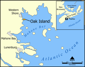
The island McGinnis, Smith and Vaughan were on was one of 300 small isles in the Mahone Bay, Nova Scotia, Canada. It was peanut-shaped and about three-quarters of a mile long and 1,000 feet wide.
Cutting away the smaller trees, the three young men started digging in the depression. After two feet they hit a floor of carefully laid flagstones. This type of slate was not found on the island and the group figured it had been brought there from about two miles north. Below the stones they saw that they were digging down a shaft that had been refilled. The walls of the shaft were scored with the marks of pick axes, more evidence that this structure was the work of men.
At the ten foot level they hit wood. At first the group figured they'd hit a treasure chest, but quickly realized that they had found a platform of oaken logs sunk into the sides of the shaft. Pulling up the logs they discovered a two-foot depression and more of the shaft. Continuing to dig, they finally reached a depth of twenty-five feet. At that depth they decided they could not continue without more help and better planning. Covering the pit over, they left. One thing the three were sure of, though, was that something must be at the bottom of the pit. They concluded that nobody would have gone to the trouble of digging a shaft deeper than 25 feet unless he had something very valuable to hide.
Nineteenth Century Excavations
Not much more was done with the pit until around 1802. While stories differ, it seems likely that the three spent the previous years searching for a financial backer to provide assistance for a more sophisticated dig. Simeon Lynds visited the money pit that year, was impressed by the story, and formed a company to support the excavation.
The work was started in the summer of 1803. After cleaning out the old pit, the crew started digging downward. Stories have it that they struck another oak platform at 30 feet below the surface. As they continued to dig they found something every ten feet: charcoal, putty, stones or more log platforms. Finally, at the 80 or 90 foot level, depending on which historical account you read, a flat stone, three feet long and one foot wide, with strange letters and figures cut into it, was found. At 93 feet deep, the floor of the pit began to turn into soft mud. Before the end of that day the crew probed the bottom of the shaft with a crowbar hoping to find something. They hit a barrier as wide and as long as the shaft. The group speculated that they'd finally reached the treasure vault and went to bed with the expectations that tomorrow a fortune would be theirs.
Returning the next day, the crew was shocked to find that overnight the pit had filled with 60 feet of water. Bailing was useless. As soon as water was removed from the pit, more flowed in to take its place. An attempt was made to dig another shaft nearby and get at the treasure by running a tunnel underneath the pit, but the new shaft flooded as soon as the tunnel got close to its objective.
Another attempt to find the treasure wasn't made until 1849. A new corporation was formed to finance the dig. This group wasn't much more successful, running into the same flooding problems that occurred back in 1802. They did manage to use a drill to probe what was below the money pit floor. A platform was constructed in the shaft just above the water level and the drill operated from there. The drill seemed to bore through levels of oak, spruce and clay. One sample recovered what appeared to be several links of chain made of gold.
While the drilling was going on, someone noticed that the water in the pit was salty and rose and fell with the tide. This led to speculation that the builders of the pit had conceived a clever trap designed to flood the pit with water if someone got to close too the treasure.
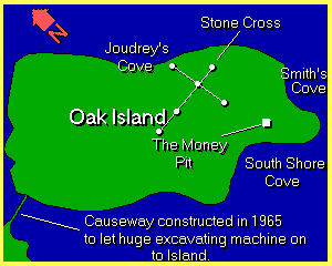
The existence of the flood trap was confirmed by the discovery that the beach of Smith's Cove, located some 500 feet away from the money pit, was artificial. Examination showed that the original clay of the cove had been dug away and in its place laid round beach stones, covered by four or five inches of dead eel grass, which was covered by coconut fiber two inches thick and finally the sand of the beach. At the bottom of all this were five box drains that apparently merged somewhere well back from the coast into a single tunnel that ran the distance to the money pit. The system was apparently designed so that the filtering action of the coconut fiber and the eel grass would ensure the drains would never be clogged by sand or gravel from the beach. It worked well.
Attempts were made to put the flood trap out of business by building a cofferdam around the cove to by holding the tides back. Later, pits were dug to intersect and plug the tunnel on its route to the money pit. These failed, and this try at reaching the treasure was given up in 1851 when the money ran out.
The next attempt in 1861 cost the first human life. The searchers tried to pump out the money pit using the steam engine-powered pumps. A boiler burst and one worker was scalded to death while others were injured. Further fatalities were barely avoided when the money pit's bottom, weakened by attempts to get at the treasure by digging up underneath from other shafts, collapsed. If there were any treasure chests they were probably carried much deeper by this crash. This dig did succeed in discovering where the flood tunnel entered the money pit, but there was still no way to turn off the water. By 1864 these searchers were also out of money.
In 1866, 1893, 1909, 1931 and 1936 additional excavations were started. Extreme methods were used including setting dynamite charges to destroy the flood tunnel, building a dam to keep the water out of Smith's Cove, and bringing in a crane with an excavation bucket. None of these approaches recovered a single coin while costing the backers a small fortune and one worker his life. One of these efforts did manage to block off the flood tunnel from Smith's Cove, only to discover more water was pouring in from the opposite direction via a natural or man-made route from the south shore. Drilling also indicated that there might be some kind of cement vault at the 153-foot level. By this time the south end of the island was full of old shafts, though, and it was increasingly hard to tell were the original money pit was located. Searchers often ran out of money just trying to figure out where the old shaft had been.
Modern Excavations
In 1959 Robert Restall, a former daredevil motorcyclist, took up the challenge with the help of his 18-year-old son. By then the Smith Cove's flood tunnel had become unblocked and Restall made it his first order of business to seal it off. He had sunk a shaft to the depth of 27 feet near Smith's Cove when tragedy struck. His son found him laying at the bottom of the pit in muddy water. Climbing down to help his father, the boy suddenly fell off the ladder and lay next to him. Kal Graseser, Restall's partner, and workers Cyril Hiltz and Andy DeMont climbed down to assist, but also collapsed before reaching the bottom. Edward White, a visiting fireman from Buffalo, New York, immediately suspected carbon monoxide poisoning from the exhaust of a nearby gasoline pump and descended the pit with a rope tied around his waist. He was able to rescue DeMont, but the others died. In one day Oak Island mystery claimed four more lives.
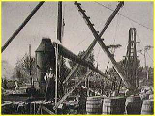
In 1965 Robert Dunfield tried to apply modern open pit mining methods to the treasure hunt. Using a 70-ton digging crane he dug a hole at the original pit site 140 feet deep and 100 feet in diameter. The dirt was carefully sifted for any treasure, but only a few pieces of porcelain dishware were found. Heavy rains dragged the work out for months and Dunfield ran out of money. The pit, and its mystery designer, had won again.
The Money Pit Today
In 1970 the Triton Alliance was formed to continue looking for the treasure. Legal battles between owners of different portions of the island resulted in slow progress. A number of holes were drilled in an attempt to locate the treasure and better understand the geological nature of the island, but no gold was recovered. Little work has been done in the area of the money pit itself as the soil is unstable. Often caverns, thought to be natural, have been found beneath the island. A video camera lowered down one borehole into one of these spaces recorded an image that looked like chests and a human hand severed at the wrist. The quality of the images was so poor, though, that positive identification was impossible.
Triton brought the Woods Hole Oceanographic Institute in to survey the island in 1995 and render an opinion on whether there is something valuable at the bottom of the pit. While their report is confidential, people who have seen it say that its conclusions are "not discouraging." Currently little work is being done on the island while disputes between the owners of Triton are being settled.
In addition to the money pit the rest of the island seems to be loaded with old stone markers of various types. The most peculiar of these are 6 boulders that seem to be laid out in the shape of a cross that is almost 900 feet long. Some wild speculation based on the cross suggest that Oak Island might be home to the long missing Holy Grail, but there is no real solid evidence to support this idea.
Possible Culprits
So, who built the money pit? And did they really put some kind of treasure down there? Was it Captain Kidd? Despite the legends it seem unlikely that Captain William Kidd ever had the chance to bury a treasure on Oak Island. He spent little time near Nova Scotia and certainly not enough to construct the money pit. Kidd did bury a cache of booty on Gardener's Island near the eastern end of Long Island Sound, but it was quickly seized by the Governor of New York.
Blackbeard, who possessed perhaps the most notorious reputation of all pirates, has sometimes been mentioned in conjunction with Oak Island, but only because he once boasted he had an underground cache for his treasure, "where none but Satan and myself can find it." Certainly many of the Oak Island treasure hunters would agree that this sounds like the money pit, but the truth is there isn't any evidence that Blackbeard conducted any operations north of Delaware.
In fact, it seems very unlikely that any pirate could be responsible for such a complex labyrinth as the pit. Pirates buried treasure because it offered a quick way to hide and recover their goods. A digging operation that must have taken several months just doesn't seem their style.
George Bates, a land surveyor in Nova Scotia, suggested that pirates had indeed built structures on Oak Island, but not for the purpose of hiding treasure. Bate's idea was that there was enough pirate activity between 1650 and 1750 off the coast of Nova Scotia to warrant several pirate groups getting together and building a dry dock to maintain their ships. To do this they sailed their vessels into Smith's Cove and built a cofferdam to seal the tiny bay off from the ocean. The flood tunnel was used to then drain the cove and leave the ship high and dry. The water flooded down the tunnel into a large natural cave underneath the island. A windmill located on top of the money pit extracted the water so the cove could again be drained for the next ship.
The weakness of Bates argument is that located on the other side of Nova Scotia, only a hundred miles away, is the Bay of Fundy. The tides in the bay drop at least 30 feet each day making it a huge natural dry dock. Why would the pirates duplicate what nature already provided?
Speaking of nature, is it possible that the money pit is a natural phenomena, not a cleverly designed vault? Certainly there are natural caves under Oak Island and the depression found by McGinnis could have been a sink hole. Unless all early accounts are completely incorrect the descriptions of the platforms carefully placed at 10-foot intervals seem to ensure that at least part of the structure is man-made.
Some theories suggest that the structures built on Oak Island may have been hundreds, perhaps even thousand of years old when they were discovered in 1795. They may have been built by Vikings visiting the New World, or by the native Micmac people who lived in the region before the Europeans appeared. Perhaps they were built by an advanced civilization that we know nothing about. Indeed the flood tunnel trap built into the pit in some ways reminds one of the false doors and granite plugs found in Egyptian tombs to prevent grave robbing.
If any of the above theories were true why did McGinnis discover the pit in the heart of a clearing? The trees around the money pit must have been cut when it was constructed. Given the rate oak trees grow, that meant someone had built the pit not more than fifty years before McGinnis stumbled across it.
Who would have hidden a treasure between 1745 and 1795? William Crooker, author of several books on the Oak Island mystery, suggests that the pit was built as a part of plot by King George III of England and several of his close advisors. On August 12, 1762, British forces captured the city of Havana, Cuba, from the Spanish. Havana was a rich, important city where much of the gold from the New World was shipped back to Spain. Two shiploads of the captured booty, Crooker suggests, was taken by the Earl of Albemarle to Oak Island. Previously the conspirators had arranged for military engineers to come to the island and build what they thought was a secret ammo dump complete with flood tunnels. Albemarle arrived with the treasure in sealed boxes. The treasure was placed in the pit, the pit was closed, and the engineers departed still thinking they had built an ammo dump.
Albemarle returned to England with the idea of retrieving the treasure later. Something, perhaps the madness that afflicted King George toward the end of his life, prevented getting the booty and it was forgotten about.
Crooker's theory raises another possibility, though. Suppose there is no treasure at all and the pit is simply an old ammo dump? We will only find out for sure when someone comes along who is clever enough, and rich enough, to beat the designer of the money pit and make a thorough investigation of what lies at the bottom.
Source: http://www.unmuseum.org/oakisl.htm
yeaaa buddy keep it comin, thanks man i repped u, i tried to rep more than once but it didnt let me
 Posting Permissions

 Reply With Quote


Bookmarks